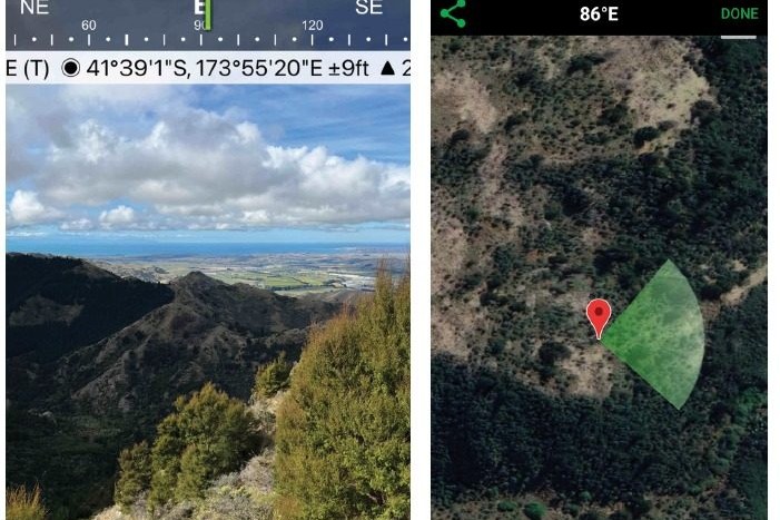
The Solocator app doesn’t just take a photo. It takes a photo showing the direction, the GPS location, time taken and the spot on the map.
This GPS field camera app costs $1.69 and can be downloaded to android or Apple smartphones.
One really useful application is photographing weed patches out on the hill, to be collated for the spraying contractor. The files can be shared in a way so they show up as way points on a map.
The app is recommended by many forestry consultants for farmer clients gathering tree samples for Emissions Trading Scheme applications. The photos can be used to prove the position of trees and indication of the site. A whole album of photos can be uploaded to DropBox, for example, then imported into a digital map. No sorting required.
The GPS coordinates on the photo prove the position. Forestry consultants can charge $120 to $150/hour to do this job so farmers can save by gathering the data themselves.
It’s handy to build historical records of the farm over time or gather information for audits. For example, a photo can prove that winter break feeding grazing was done correctly by a time-dated image of the block at feeding.
Ditch GPS, use phone
It’s quick and cheap to use a smartphone as a GPS.
For $5.99 the New Zealand Topo maps app pro can be downloaded to a smartphone (2021 Atlogis version). It downloads to android best but Apple phones can use the very similar NZ Topo50 offline app created by Land Information New Zealand (LINZ). The options are either North or South Island maps ($5.99 each).
The apps give a detailed topographic map on a phone and locate where you are by connecting to at least 35 satellites overhead. They can measure distances and heights, record tracks and mark important features.
Onfarm uses are endless. Waypoints can be added to the map, either while you are standing on the spot, or imported as a file. Weed patches can be quickly marked on a map, and then the waypoints exported to the spraying contractor. The files can be in GPX, KML, KMZ or CSV format. In other words – a great range of file types. They can be texted, emailed or sent via WhatsApp within seconds.
Broken wires needing repairs can be pin-pointed with accuracy. Pasture sampling sites, or water quality testing sites can all be added as waypoints. Records of farm pipes and other underground infrastructure can be ‘GPSed’ into a map and saved.
A route between two points can be stored on the map. This could show the best access way to a site, or to help new shepherds know where to start mustering on a block and the best route through it. For health and safety, it could mark hazards that someone needs to go back to attend to.
It states the distance to a certain spot and indicates which direction to walk in to get there, using the compass. It is useful for monitoring and farm records. Landowners needing to measure regenerating forest or prove evidence of tree cover for example, will find it straightforward to get to allocated way points. When used in conjunction with the Solocator app, a photo of the phone screen with the GPS coordinates, alongside a tree stump, is enough to prove that the tree is in the required location.
Some of the old handheld GPS only pick up 12 satellites. Most Smartphones will pick up 35 satellites, making it accurate and quick to locate where you are. Just make sure you are standing outside.
Save on phone power by running on airplane mode. No internet or cell phone connection is needed.
Overlay maps are available including open hunting areas, DOC huts and tracks. It’s worth buying a version as the free versions can be limited (e.g. only three waypoints and no route recording or importing of waypoints).

